
Thunderstorms can be cellular, or they can form a more extended line. When they develop in a line, it can be broken down into three primary regions; the leading convective edge, the transition region, and the stratiform region. Though these are the three main regions, the rear inflow jet, and bookend vortices can also play an essential role in squall lines.
Lines of storms, sometimes called squall lines or Mesoscale Convective Systems (MCS), often begin as a group of isolated thunderstorms that develop and eventually evolve into a line. In environments that are conducive to the development of a squall line, winds are roughly parallel to the boundary along which the individual thunderstorms develop. Below is a radar loop of a squall line moving through Arkansas from February 24, 2018.
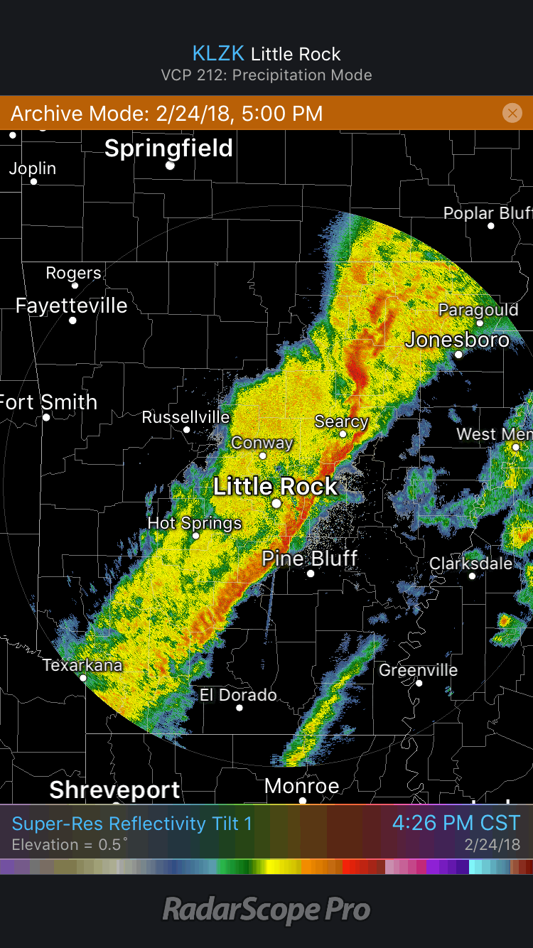 Squall Line Radar Loop
The leading edge of the line is typically where the heaviest of the precipitation and the most robust winds occur. Behind the leading edge is the transition zone, which is characterized by lighter rainfall than on the leading edge. This zone separates the heavy rain of the leading edge from the stratiform region. Reflectivities are typically low within the transition zone. Behind the transition zone is the stratiform region; within this region, reflectivities can be higher than those in the transition zone, but less than those in the leading edge. This increased reflectivity in the stratiform area can be due to an increase in precipitation intensity or the melting of precipitation. This melting causes a band of increased reflectivities known as a bright band.
While the three regions described above are the main parts of a squall line, there are other notable features. One of these features is known as the rear inflow jet. The rear inflow jet develops as warm air moves aloft with cold air beneath it. The colder air causes a small area of high pressure to form at the surface. With the warmer air aloft, an area of low pressure develops. As a result, the flow diverges at the surface and converges aloft. This area of convergence at the rear of the storm is known as the rear inflow jet. In a radar image, the rear inflow jet is indicated by a notch of low reflectivity on the backside of the line.
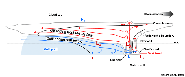 Cross Section of a Squall Line
When vertical shear is strong, a squall line may evolve into a structure known as a bow echo. At the ends of the bow echo, some areas may spin. These are known as bookend vortices. The vortex as the northern end of the bow echo rotates cyclonically while the one at the southern end rotates anticyclonically. Occasionally, a tornado may develop in association with the northern bookend vortex. If both vortices are close together, they can help strengthen the rear inflow jet described above. Below is an example of a bookend vortex.
Brief circulations continuing to spin up beneath the bookend vortex. pic.twitter.com/8wRtVQCnqe
— Tim Cermak (@toweringCU) August 6, 2017
Knowing the structure of a squall line and its associated features can help anticipate what to expect if you’re in the path. RadarScope can provide the data needed to identify the signatures described above so that you can prepare before the storm arrives.
{{cta(‘7adc9887-5a2e-4a2c-90de-3d3a733f8912′,’justifycenter’)}}


