
The third part of the series will focus on various forms of ground clutter and miscellaneous things like smoke and chaff. Ground clutter is generally characterized by isolated, noisy large values of reflectivity and velocity that move very little if at all. Sometimes there will be pixels of missing/no data/zero within a group of pixels with high values. The correlation coefficient is generally very low, and differential reflectivity tends to be near zero but can be variable. When watching a loop, it tends to suddenly appear and disappear in the same area, rather than moving. Some ground clutter is almost constant, but in general, it tends to be worst during the night or early in the morning. Smoke and chaff can be most readily distinguished from precipitation by the low correlation coefficient. Satellite data can also be helpful for determining if there is a fire or significant cloud cover in the area of interest.
Part 3- Ground Clutter and Other Stuff
1. Wind Farms
One of the most common ground clutter artifacts that attracts significant attention is wind farms, mostly because of the tendency for very high reflectivity that looks like a thunderstorm. Wind farms are distinguished on radar data as small regions of very high reflectivity that don’t move. It has unrealistically large reflectivity gradients along the edges (goes from nothing to 60+ dBZ in one or two pixels) and noisy values in the interior (a 40 next to a 50, next to a 70, next to a 30, etc.). Sometimes, it is possible to see the individual rows of turbines, as in the example from Dodge City. The satellite layer on Google maps can confirm the presence of a wind farm. There is also a map of wind turbines maintained by the USGS, though it may not include some of the newest wind farms. Some radars, such as KVNX, KDDC, and KDAX, have nearby wind farms that always show up, but most only show up on radar when the beam stays closer to the ground than normal, usually early in the morning. Even though the turbines themselves don’t move, the radar will frequently display non-zero velocity in wind farms because of the spinning blades.
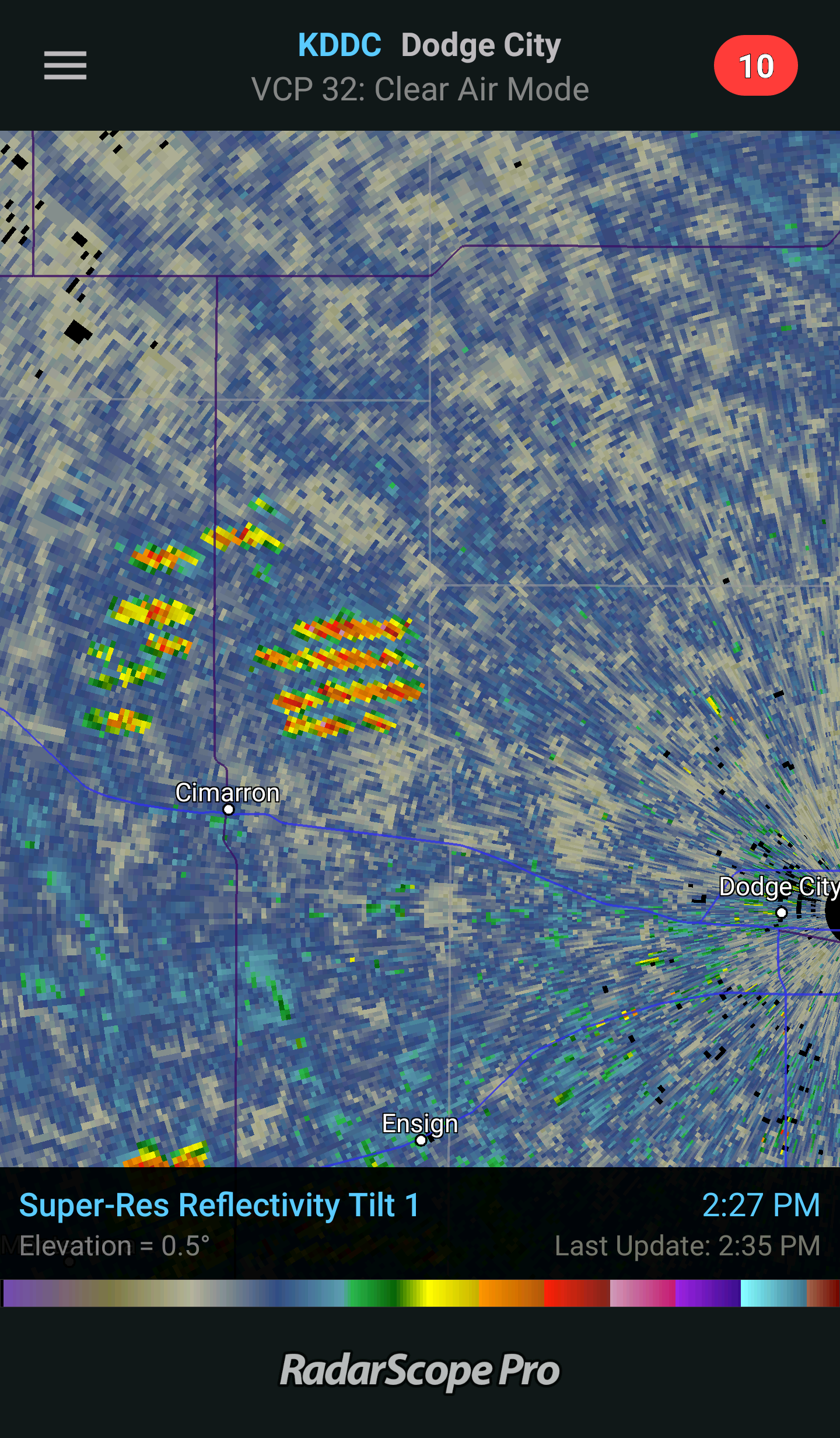
Wind farm very close to the Dodge City radar where the rows of turbines can be seen in the reflectivity data.

Very large wind farm just east of San Francisco Bay.
2. Anomalous Propagation
Additional ground clutter beyond what is always visible for a given radar site sometimes appears as a result of “anomalous propagation” or AP. This type of clutter occurs when the vertical temperature and moisture profile is such that the radar beam is bent back toward the ground more than usual. Its time near the ground is then prolonged, and it can encounter biological scatterers and in some cases contact with ground-based targets such as hills, trees, etc. AP is most common overnight or early in the morning, but can also occur behind thunderstorms or strong cold fronts. Below is a severe example from Dodge City, which includes some wind farms also. Even though it looks like widespread rain near Larned and St. John, that is all ground clutter. The morning sounding from Dodge City shows the dramatic increase in temperature and decrease in moisture just above the surface that produced the anomalous propagation conditions.
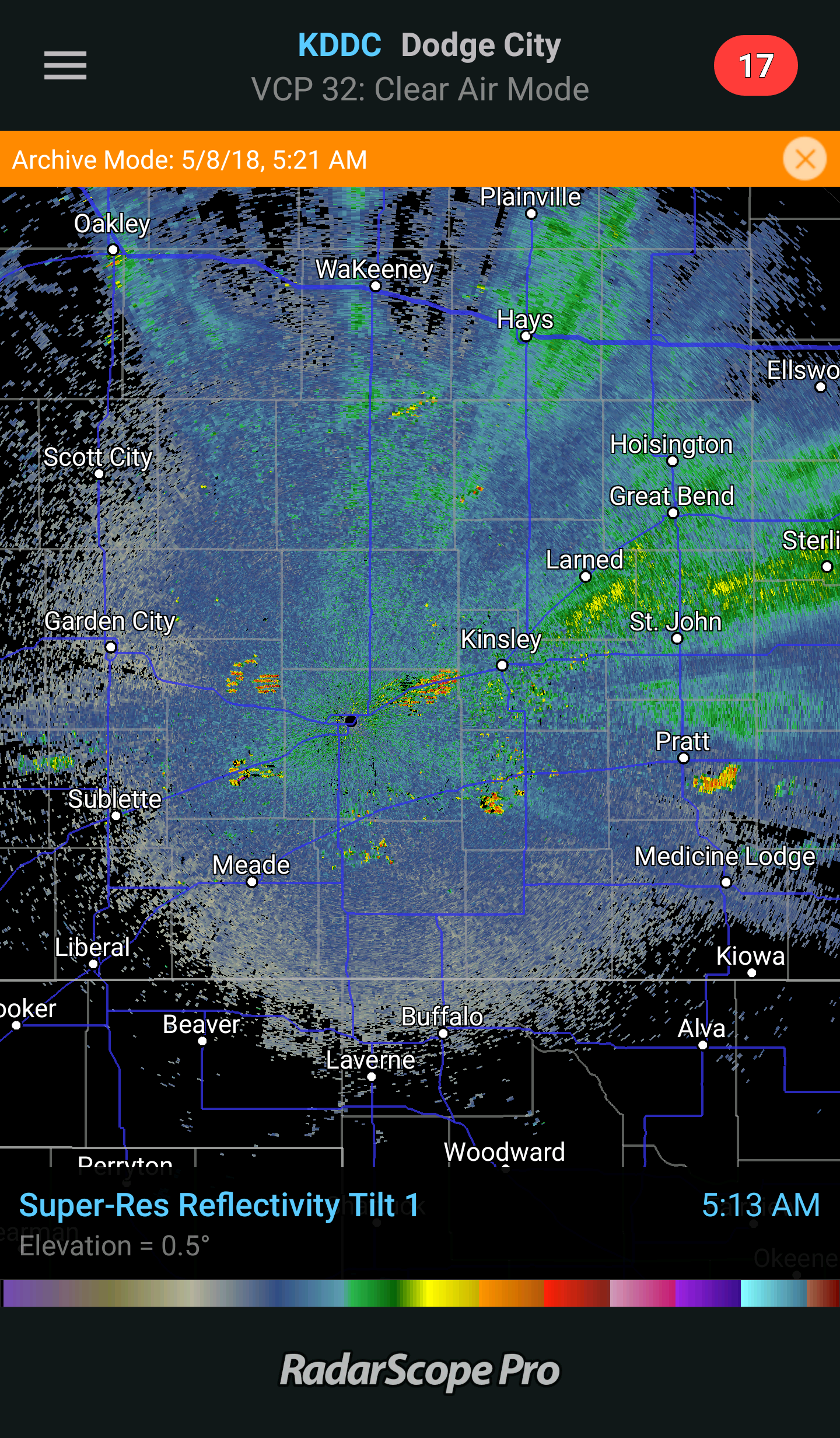 Widespread clutter echoes (some biological, some ground-based) near Dodge City.
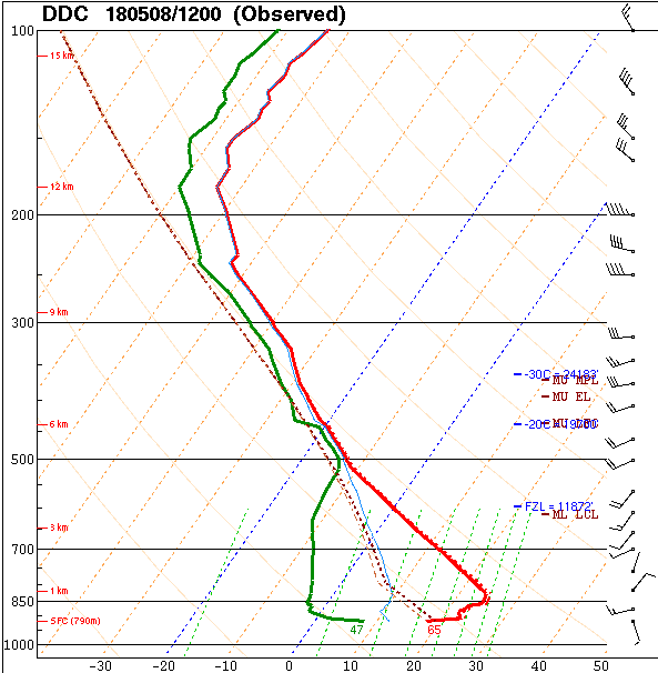 Observed sounding (skew-T diagram) near the time of the above radar image. The red line is temperature, and the green line is dew point. Note that just above the surface temperature increases and moisture decreases sharply. This vertical gradient causes the anomalous propagation of the beam, which in turn causes the clutter echoes.
3. Cars on Interstates
Sometimes radar will pick up vehicles on interstates or other highways near the radar. There will be a few pixels of high reflectivity and generally large velocities (of either/alternating sign) right along the road (if the highway layer is on in RadarScope).
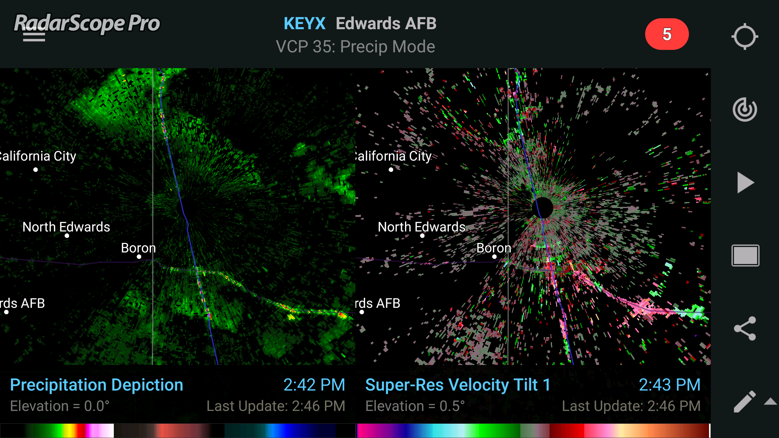 Reflectivity and velocity image from Edwards AFB, CA radar showing vehicles on multiple nearby highways.
4. Smoke
Smoke from large fires sometimes shows up on the radar as a plume moving downwind and spreading out from a source point. One of the distinguishing characteristics of smoke in dual-polarization data is the very low correlation coefficient. While not as evident a distinctive trait as the correlation coefficient, differential reflectivity sometimes shows a pattern where it is low near the fire, and becomes quite large near the edges of the plume. This signature is likely because the particles making it to the outer edges of the plume are larger, flatter particles gliding with a horizontal orientation and staying aloft longer, while the center of the plume has a greater variety of orientations and shapes. Below is an example of a massive fire along the Oklahoma-Kansas border in 2016.
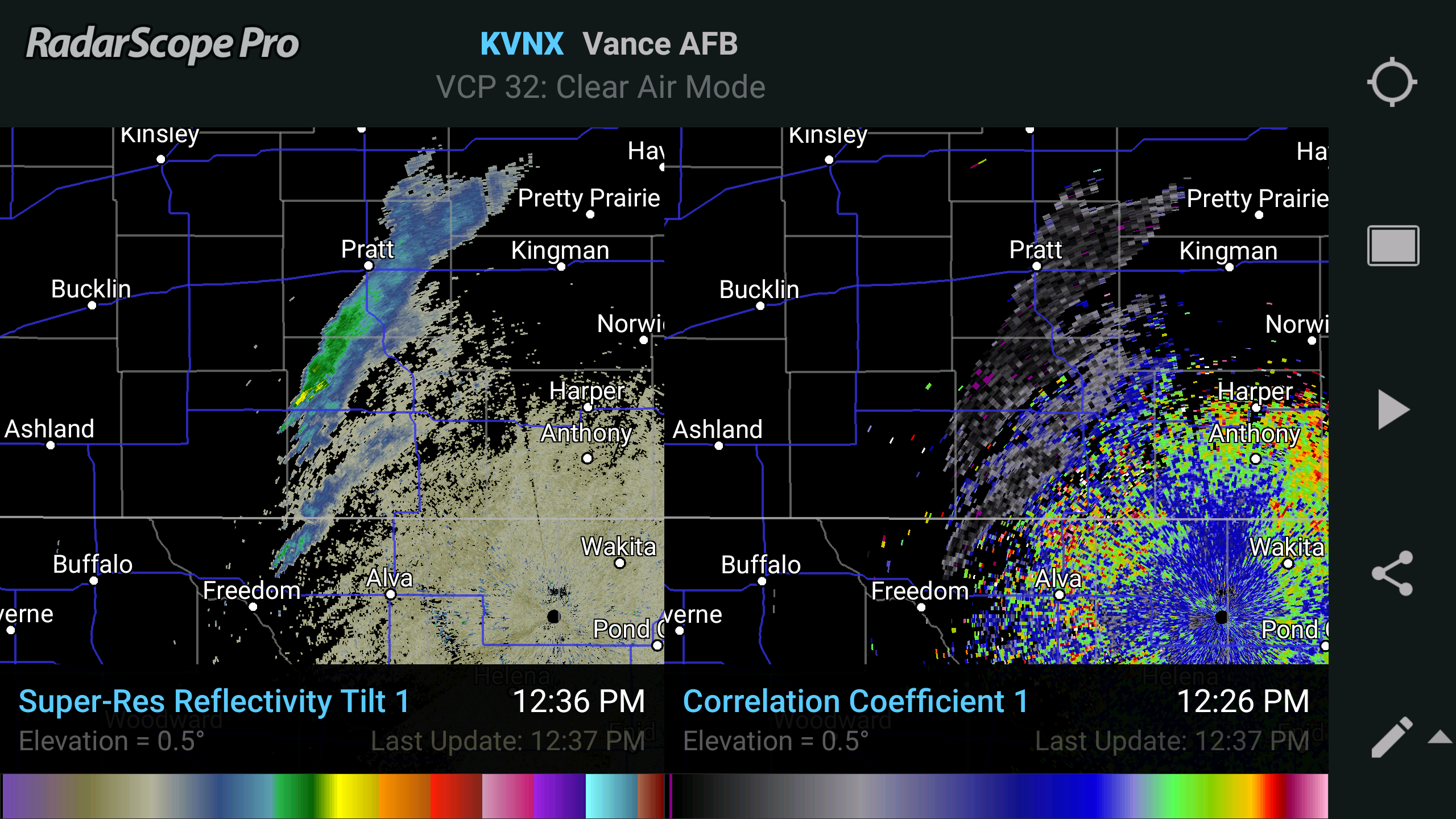 Image of Reflectivity and Correlation Coefficient showing smoke plume blowing northeast from a large fire.
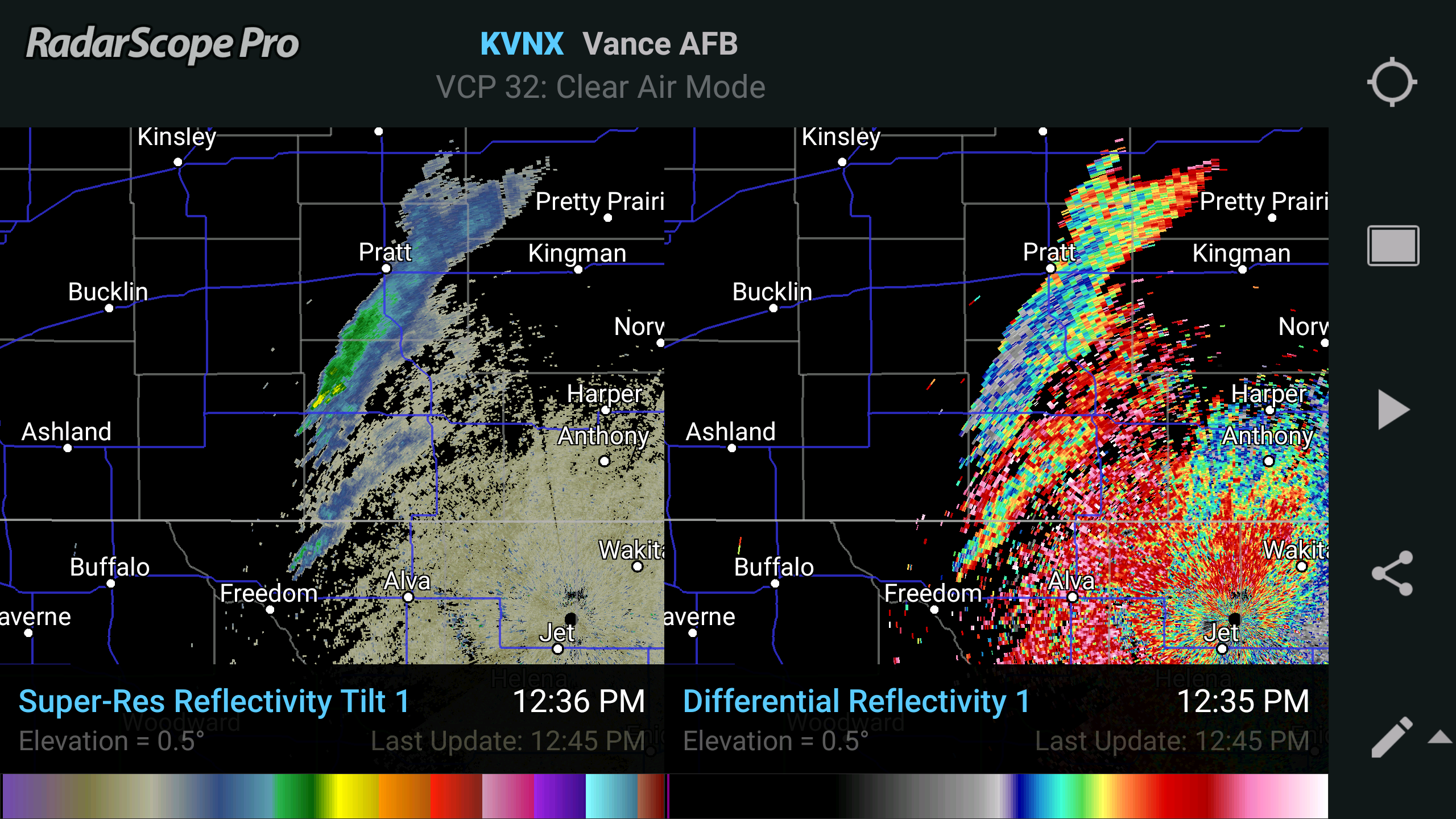 Image of Reflectivity and Differential Reflectivity showing smoke plume blowing northeast from an enormous fire.
5. Chaff
For military exercises, aircraft will sometimes release material into the air called chaff, which are strips of aluminum foil. Chaff is designed to be highly reflective and mask out aircraft by flooding the radar with echoes. Like smoke, chaff also drifts with the wind, but it is usually released along the flight paths of airplanes and possibly intermittently, so it isn’t always a smooth plume as with smoke. These radar echoes can be some of the most convincing impostors for precipitation because it moves like precipitation. One or more areas of high reflectivity drifting with the wind that isn’t precipitation or smoke is probably chaff, especially if there is a military installation nearby. In this example, the area of chaff looks like a heavy rain shower, but the very low correlation coefficient indicates that it is non-meteorological.
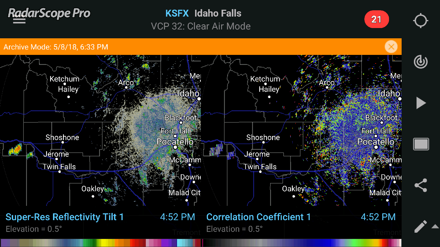 Loop of Reflectivity and correlation coefficient from KSFX in Idaho showing chaff.
In this series, we have examined most of the non-precipitation features that can be commonly observed with RadarScope. Some of them tell us useful things about the atmosphere, such as the boundaries in part 1 and the anomalous propagation in this part. Others can be used by biologists to study birds, bats, or insects, and some are just stuff the radar happens to see at times. What other interesting things can you find on RadarScope? Try it today!
{{cta(‘7adc9887-5a2e-4a2c-90de-3d3a733f8912′,’justifycenter’)}}


